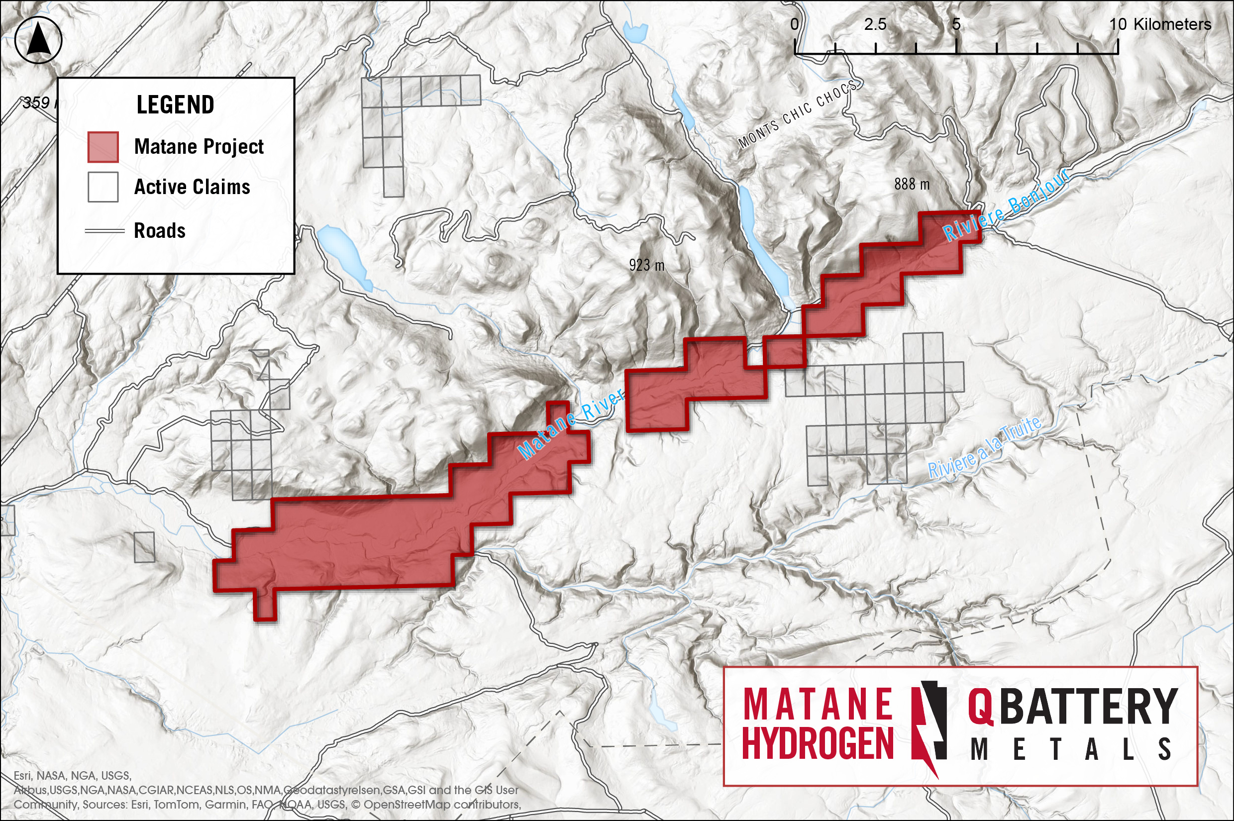
The Matane Project consists of two blocks of 76 cells (claims) distributed along a SE-NW orientation and following the trajectory of the Shickshock-South fault zone. Along this axis, the property extends over 26 km. According to the Gestim website, mineral exploration is permitted in this area, which is located on public land.
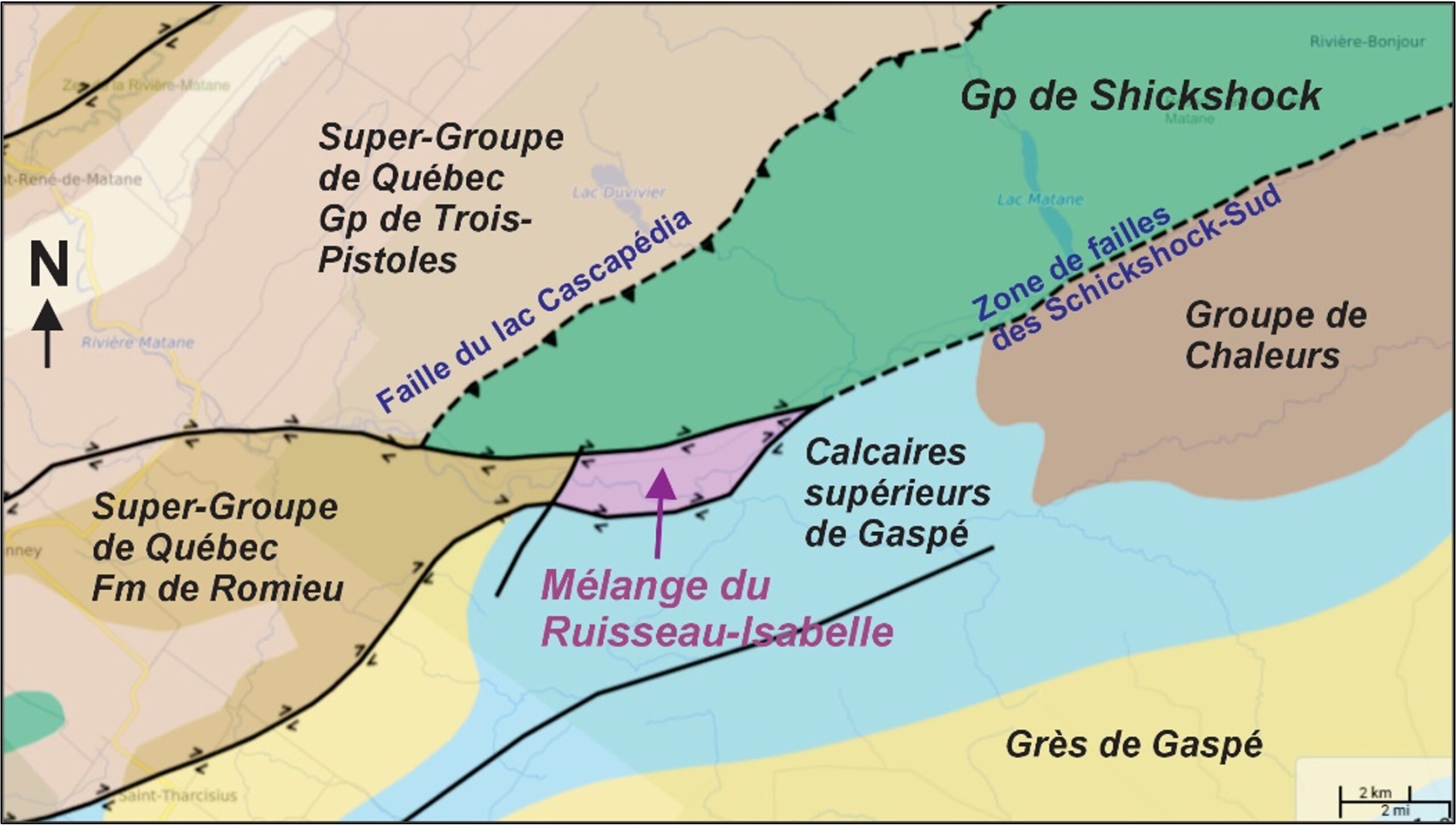
The Matane project is a hydrogen exploration initiative in the Appalachians of Québec, positioned in a transition zone between Cambro-Ordovician (Taconic) and Siluro-Devonian (Acadian) rocks. The area holds strong hydrogen potential, with key basaltic (Schickshock Group), peridotitic (Isabelle Brook Mixture), and arkosic sedimentary rocks present in a tectonized zone. Basaltic and peridotitic rocks may generate hydrogen through oxidative hydrolysis, while arkosic rocks could contribute to hydrogen and helium production via radiolytic reactions from potassium decay.
The Schickshock-South fault plays a crucial role, marking the boundary between Cambro-Ordovician and Siluro-Devonian formations. The latter contains calcareous sedimentary rocks known for natural gas reservoirs in the Lower St. Lawrence and Gaspé regions, suggesting a favorable geological context for hydrogen and helium accumulation.
matane Project location map
Click to enlarge
matane Project geology map
Click to enlarge
Matane hydrogen project
Project geology
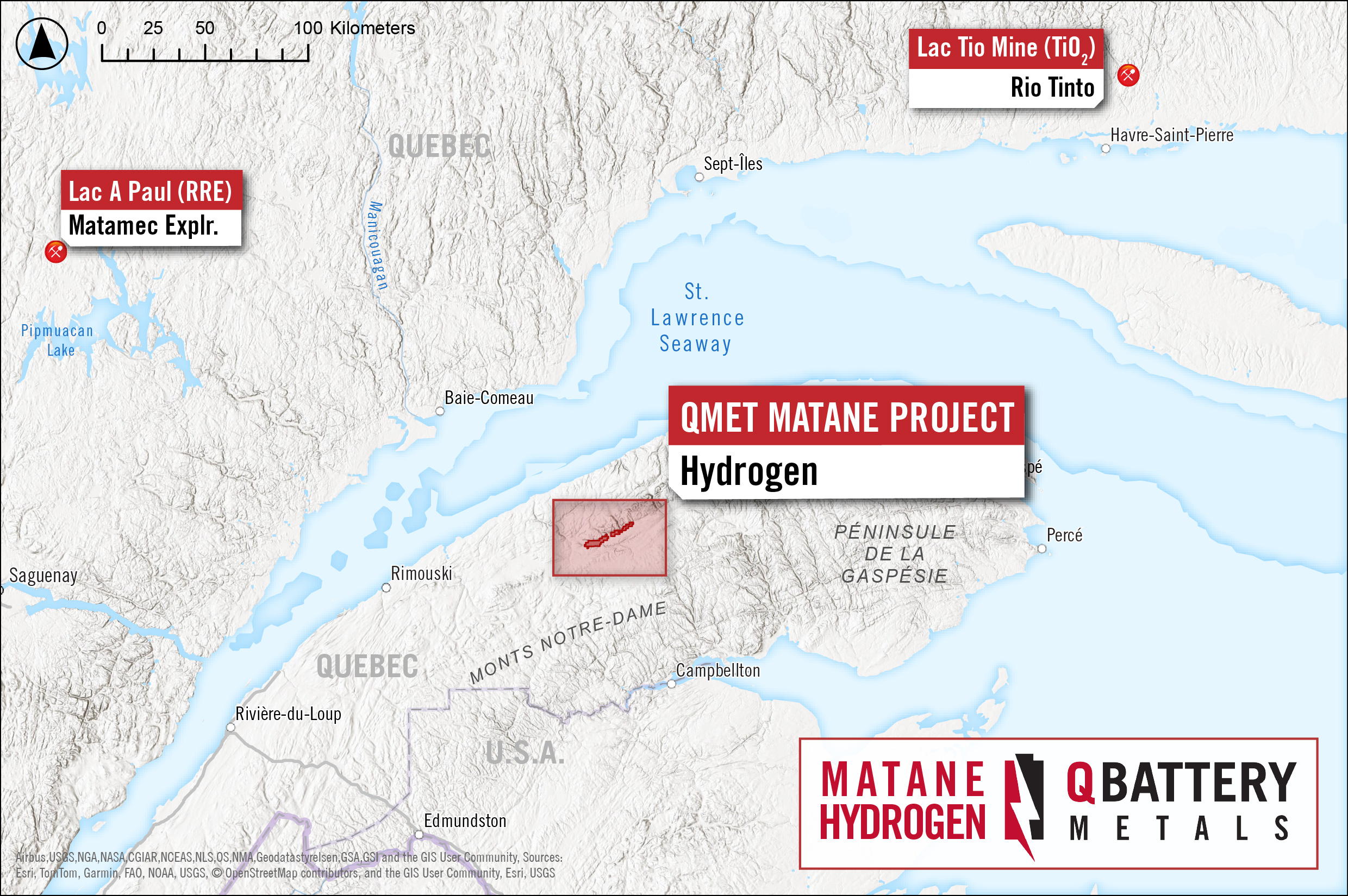
The Matane Project is a public forest exploration area situated southeast of the town of Matane, within the western part of the Matane Wildlife Reserve. The site is easily accessible via Route 195, traveling 30 km south from Matane, then heading west along the wildlife reserve road.
Located in the Lower St. Lawrence region, the project falls within the La Matanie RCM and the unorganized territory of Rivière-Bonjour. It is mapped on NTS sheets 22 B/10 and 22 B/11.
GEOLOGICAL ADVANTAGE:
The geomorphology, topography, and hydro-geological conditions of the Matane project area are distinctive, featuring a steep vertical drop of approximately 500m, high rainfall, and heavy snowfall during winter.
Within a hydrogen production model, this setting may be particularly favorable for hydrogen generation, driven by the interaction of deep groundwater (fault zones) with mafic and ultramafic rocks.
Matane hydrogen project
Project geology
The geology of the southwestern extremity of Réserve faunique de Matane consists of Paleozoic rocks belonging to the Appalachian tectonic province. The Matane project area is equally divided between Cambro-Ordovician rocks (Taconic orogen) to the north and Siluro-Devonian rocks to the south (Acadian orogen), which belong to the northern part of the Gaspé Belt, i.e. the Connecticut Valley-Gaspé Synclinorium.
The Cambro-Ordovician terrains are dominated by sedimentary rocks and Neoproterozoic basaltic rocks of the Shickshock Group (Quebec Supergroup) and by Ordovician rocks of the Ruisseau Isabelle Mixture.
The rocks in the study area were first deformed during the Middle Ordovician (Taconic orogeny). These deformations were responsible for the formation of overturned folds, thrust sheets and tectonic scales.
These rocks were also affected, to a lesser degree, by the Acadian orogeny (Middle to Late Devonian). Siluro-Devonian strata were much less deformed during the Acadian orogeny. They consist mainly of mudrocks, sandstones (e.g. Gaspé Sandstone) and limestones (Gaspé Upper Limestone), interbedded with basaltic and rhyolitic lavas and felsic volcanoclastites.
matane Project geology map
Click to enlarge
matane Project geothermal map
Click to enlarge
Click to enlarge
Matane hydrogen project
POTENTIAL FOR HYDROGEN
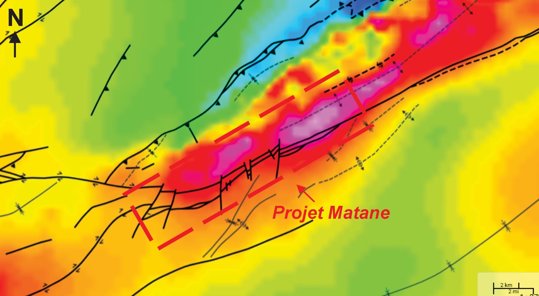
The zone of peridotite-rich rocks (ultramafic rocks) in the Isabelle Creek mélange follows the Shickshock-Sud fault zone for over 17 km. This formation is considered a priority hydrogen target due to the presence of olivine-bearing ultramafic rocks (e.g., Mt-Albert Complex), iron-rich basalts and arkose in the Schickshock Group, and the Shickshock-South fault zone, one of the most significant fault structures in the Lower St. Lawrence and Gaspé regions. A topographic trench with a vertical drop of nearly 500 m creates an ultra-favorable setting for groundwater recharge through surface water infiltration. The presence of faults within the trench is ideal for deep groundwater transfer, enhancing conditions for hydrogen formation. With a higher geothermal gradient in the Appalachians compared to the Canadian Shield (e.g., Abitibi), the combination of abundant water, deep fault structures, and hydrogen-bearing source rocks provides an optimal model for hydrogen and helium generation.
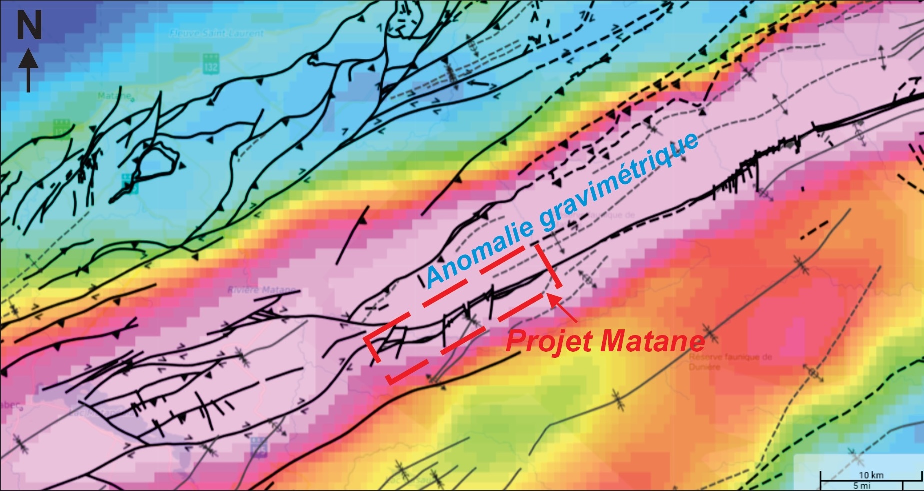
The Matane Project area corresponds to a E-W to SE-NW magnetic anomaly along the Shickshock-South fault zone, emphasizing the lateral continuity of ultramafic rocks (peridotites) in the region. Additionally, gravity anomaly data indicate the presence of denser rock formations than surrounding sedimentary units. The substantial volume and thickness of mafic and ultramafic rocks in this area are likely responsible for generating a pronounced linear anomaly.
This geological context is particularly favourable for natural hydrogen production.
Subscribe To Our Newsletter
Get notified about the latest company news and updates by signing up below.